Get Flood Insurance San Jose CA & Save Money Too.
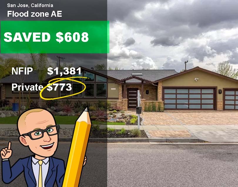
People in San Jose CA save on average $500 to $1,457+ on their annual flood premiums.
In many cases, we save them even more. Get the cheapest flood insurance in San Jose, CA, without sacrificing coverage.
To speak with a Flood Nerd call 866-990-7482

featured on

San Jose CA Flooding
San Jose CA Floodings & flood insurance in San Jose CA
To understand if your property is at risk of flooding.
First, you have to understand all waterways and bodies of water are subject to floods in and around San Jose.
Flooding in San Jose is caused is when the volume of water exceeds the capacity of the rivers, streams, brooks, canals, lakes, and spillways.
With 180 miles, There are many flood maps in San Jose, CA the fourth-largest city in the land area also has the potential of tidal waters pushing inland by coastal storms along the Bay area.
Flooding will occur in localized low spots, even if the area is not close to a body of water.
San Jose CA can be prone to flash floods & mudslides.
Flood Map San Jose CA
FEMA, which stands for the Federal Emergency Management Agency is the government branch charged with keeping us safe.
Since 1973 FEMA has taken on the massive mandate to map all the flooding risks across the country. These are Called FIRM or Flood Insurance risk maps.
According to FEMA flood maps done for San Jose CA, Palo Alto Ca, Milpitas CA, Sunnyvale, and Santa Clara are considered one of the most at-risk areas to see flooding.

★★★★★
"Same Coverage at a Better Rate"
-Mohammed K
Flood Nerds will shop the private flood insurance markets and then compare them to the NFIP, guaranteeing you the better option. We will send you the cheapest flood insurance rates within minutes.

★★★★★
"Quick Response, Very Knowledgable"
– Robert W
Paying for low-cost flood insurance is awesome. And letting the Flood Nerds shop your property has other benefits – you can get better coverage while saving money, and you can get it fast.

★★★★★
"Would highly recommend Better Flood for your flood insurance needs."
– Varun K
Better Flood Insurance is an independent flood insurance broker that shops flood insurance ONLY. Flood Nerds are Flood insurance experts. We have 5000+ happy clients and 390+ 5-star reviews.
Flood Insurance San Jose CA
There will be new maps for San Clara County CA, as well as San Jose CA coming in the next few years.
San Jose CA has 6,969 properties in the high-risk flood zone.
FEMA flood maps that will take effect have the potential to send the insurance cost for these properties up.
The good news is that you have a flood nerd on your side.
Flooding in San Jose CA and 100-year flood map
FEMA came up with this term, the 100-year flood zone, and it is very confusing.
Using the 100-year flood risk as a guide, FEMA mapped San Jose CA into high risk, moderate-risk, and low-risk flood zone.
Several areas within San Jose CA city limits and Santa Clara County are considered high-risk flood zones or Special Flood Hazard Areas (SFHA). This means that structures in these areas (flood zone maps) have a one-in-four chance of flooding at least once during a thirty-year period.
Please note that moderate or low-risk flood zones do not mean that there is no risk.
It just simply means that your property might not be required to purchase a flood policy by their lender. It doesn’t mean that the property won’t flood.
If your property is within the high-risk San Jose CA flood zone map and you have a mortgage, your lender will require you to purchase a flood insurance policy.
Our Government wants us all to have flood insurance coverage, and in light of recent flooding events, I would agree with them.
Anywhere it can rain, it can flood. This is even more critical in areas where there is minimal perception.
All you would need is a small shift in weather patterns to get more water than has hit the region in a long time.