What is BFE (Base Flood Elevation)? Get the Answer Now and Save Money on Flood Insurance
What is Base Flood Elevation (BFE)? Understanding the Flood Plain Jargon
Have you ever tried to navigate the waters, so to speak, of flood plain management? Trust me, as someone who has been in the real estate flood insurance game for a while, I know how complicated it can all seem. And the government certainly doesn’t help with its jargon-filled definitions and regulations, including the Base Flood Elevation or BFE. But don’t worry, today we’re going to break down what BFE really means, and why it matters to homeowners and property owners.
First things first: Base Flood Elevation map refers to the elevation or height to which a flood is predicted to reach during the base flood. The base flood is defined as a 1% chance of a flood of that size occurring in any given day on any given year. For example, if an area has a 1% chance of a flood reaching a certain height in any given day, that height is the Base Flood Elevation for that area. Because floods are unpredictable, this number is based on statistical analysis of the likelihood of a flood and the possible damage it might cause.
But why does my BFE matter?
That’s where the regulations come in. The National Flood Insurance Program (NFIP) uses the base flood as a national regulatory standard to reduce the risks of flood damage. The Federal Emergency Management Agency (FEMA) and other Federal agencies employ the base flood to require the purchase of flood insurance and regulate new development. In short, the BFE can impact the cost of your flood insurance and your ability to build on or modify your property.
So, what is my BFE?
FEMA provides maps called Flood Insurance Rate Maps (FIRMs) that show the boundaries of a community’s flood plain, and provide specific data to determine the BFE for each location. Keep in mind, however, that FIRMs aren’t perfect and don’t necessarily reflect the current state of your property or the likelihood of future floods. If you’re unsure of your property’s BFE or require more information, FEMA’s website provides resources and contact information for local floodplain management officials.
It’s also worth noting that BFE isn’t the only factor to consider when assessing your flood risk. Other factors like the slope of the land, the presence of bodies of water nearby, and the property’s elevation all play a role. In fact, even properties outside the designated flood plain can still be at risk of flooding. Additionally, FEMA updates its flood maps periodically based on new information, so it’s important to stay up-to-date with the latest regulations and developments.
In summary, Base Flood Elevation is a crucial aspect of flood plain management, and can have a real impact on your property’s insurance and development potential. While navigating the regulations and jargon can be daunting, understanding the basics of the BFE can help you make informed decisions and protect your investment. By researching and staying up-to-date with BFE and other flood safety measures, you can ensure your property and family are properly prepared for anything Mother Nature has in store.
Ok now in the Flood Nerds Terms.
What’s my BFE?
Base Flood Elevation is how high the water might get if there is a flood. It’s like a guess based on how likely it is for floods to happen in that area. The number tells us what height the water might reach during a really big flood, like one that only happens once every twenty, fifty or one hundred years.
Why is BFE important? It tells us what regulations to follow. The NFIP uses the base flood as a national rule to help determine which properties will be required to purchase a flood insurance policy. FEMA, local community and lenders use the base flood for people to buy insurance, and also when building or changing property. BFE affects if you will have to buy flood insurance and if you can build and how high you need to build on your land.
To figure out the Base Flood Elevation for your property, look at maps from FEMA. The maps are called Flood Insurance Rate Maps, and they show the area in your community that might flood. But these maps aren’t always right. If you need more help, go to FEMA’s website for resources or contact information for people who know about flood insurance your flood nerds.
How does the Base Flood Elevation (BFE) impact my flood insurance premiums?
For more than half a century, the National Flood Insurance Program (NFIP) has been the exclusive provider of flood insurance. The program utilizes the Base Flood Elevation (BFE) to create flood insurance maps revealing areas that require flood insurance, along with how much it will cost in premiums. The age of the property and foundation also factor into the equation. That being said, if you’re seeking alternatives, the private flood insurance market relies on distinct flood insurance rate maps, which can yield savings of up to 50% compared to the NFIP. We search for all the available options in your area to help you find the best premium possible.
How do I find the Base flood elevation for my property?
The base flood elevation for your property can typically be found on FEMA flood maps or by contacting your local building or zoning department. You can also hire a licensed land surveyor or engineer to determine the elevation for you.
Best way to really know is to ask a flood nerd to shop your property we can tell you your BFE.
To check your property’s base flood elevation map, you can use this link. However, understanding the map can be tricky unless you know what you’re doing. Your best bet is to ask a flood Nerd to assess your property. They’ll explain everything you need to know without any confusion.
What is my BFE elevation?
There are basically two ways to figure out your Base flood.
You can fill out our intake form for your property and put in the notes that you are wanting to know what your BFE is. (Intake form here)
Or you can go to this site and put your address in to look at your property in relationship to the flood map.
Base flood elevation example
The illustration below showcases each of the BFE’s distinctly. For level terrain, it may be necessary to meticulously search the flood map to pinpoint the identifiable BFE.

How high do I have to build above the base flood elevation map?
When constructing a new structure in a high-risk flood zone, it is advisable to keep it approximately two feet higher than the existing Base Flood Elevation (BFE). It is also essential to collaborate with the local flood zone authority to ensure compliance with the Federal Emergency Management Agency’s (FEMA) building guidelines for a flood zone.
What if I have a property without a base flood elevation Zone A, Unnumbered A flood zone
Living in an unnumbered A flood zone without a BFE is a risky affair, especially if your community hasn’t established the BFE with FEMA. Constructing a structure without an accurately established BFE can be a hurdle as it might not be elevated enough to withstand floods. Collaborating with your community officials is crucial to establish a site-specific BFE. On a positive note, preparing your own Elevation Certificate for an unnumbered A flood zone is possible without a professional surveyor, saving you some bucks. Simply fill out Section E on the certificate and be on your way to a safer living environment.
Check out these other resouces
Private flood insurance
Lloyds of London Flood Insurance
NFIP vs Private Flood Insurance
The Following is a Conversation with a Client about BFE
What is my Base Flood?

Hi Robert, I need to know my BFE since we talked about it before, can you please let me know what it is? I want to get my base flood elevation.

Hey Dewitt! Great to hear from you. Sorry we missed each other earlier. Claudia mentioned you’re checking the BFE for your Arvada property. Just so you know, other properties might have slightly different levels. Here’s the 303 on your property:
ARVADA, CO 80004
BFE: 5412
I’ve attached the Flood Zone determination. Are you thinking of pursuing a LOMA or elevating the building? Lemme know if there’s anything else I can do to help!
– Your friendly neighborhood Flood Nerd, Robert

Hi Robert, sorry I missed your call. I am trying to figure out how to find base flood elevations for all the houses in Arvada that are in the floodway. Is this possible?

May I inquire if you possess the ability to read maps proficiently? Kindly navigate to the following website:
Enter your address for us to locate you in the FEMA Flood Map
ARVADA, CO 80004

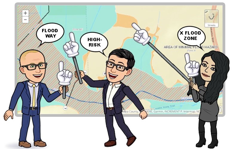
The diagonal multicolored lines indicate the Floodway while the light blue color represents the flood zone. You may refer to the BFE numbers on the map to get a better understanding.
For those who are interested in exploring more in-depth, the official and historical maps of the area’s entirety are accessible by clicking on the following link.
https://msc.fema.gov/

Thanks! I’ll give it a shot.

Wishing you an enjoyable time!
What does “5412” signify? I ask because I noticed “5408” on the map proximate to my property.

Hello Dewitt, I appreciate your interest in FZD (Flood Zone Determination). It is an official record that remains specific to each property, and the attached document provides further details. The map-linked in the email displays 5408, symbolic of your home’s vicinity, as you’ve already pointed out. The BFE or Base Flood Elevation (5412) from your flood zone determination report indicated the floodwater’s expected highest level, as concluded by the core of engineers. Acquiring an Elevation Certificate from a FEMA-approved surveyor is necessary to determine your property’s accurate elevation. Ideally, your home’s position should be higher than the BFE standard, i.e., the Lowest Adjacent grade (LAG). Feel free to call me tomorrow if you want to discuss whether obtaining an elevation certificate would be appropriate for you. Here’s my number: 1-866-990-7482. Best regards, Your Flood Nerd, Robert Murphy.
Flooding is the primary cause of financial ruin in the United States, representing the most substantial claim that most uninsured homeowners will face, occuring more frequently than one might realize.
Often, we take for granted the water bodies that flow close to our homes – the streams, creeks, brooks or rivers. Their serene babble sounds beautiful, luring birds and wildlife towards them. It’s easy to forget that in an instant, these same waters can turn menacing and devastate our homes, leaving families with nothing.
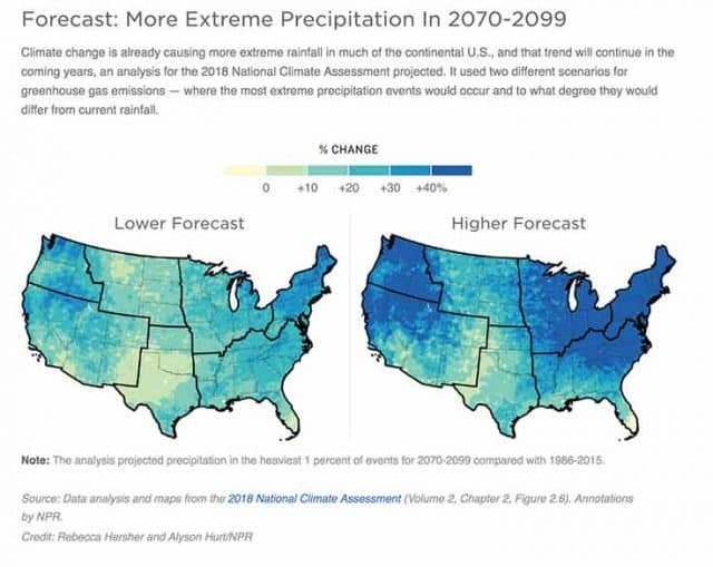
Tragically, disasters seem to be on the rise across the country – a 2018 climate change report shows that the number of US counties experiencing disasters has doubled since the year 2000, from under 20% to about 50% today. To help communities rebuild and prevent future disasters, the federal government spends billions of dollars annually from our taxes. But for those affected, the financial consequences can be catastrophic, with bankruptcy ruining their futures.


